Eastern Communities on The Divide 1803 Through 2020

G – Gwillimville SV – Spring Valley TR – Table Rock E – Eastonville H – Husted P – Pring
- 1803 – The Divide was acquired as part of the Louisiana Purchase.
- 1832 – Region described as “hostile ground” on a map by George Catlin.
- 1840’s – Fur trappers frequent the Divide along Trappers Trail (aka the Government Road, Jimmy Camp Trail) near present day Meridian Road.
- 1843 – John Charles Fremont Expedition traversed the Divide describing it as a piney elevation.” Sought shelter from Indian attack near the Bijou Basin on a bluff known as “Fremont’s Fort.”
- 1845 – Colonel Stephen W. Kearney crosses the Divide to discourage Indian attacks on wagon trains.
- 1846 – Francis Parkman retraced Fremont’s steps and was caught in a big storm near Black Squirrel Creek.
- 1849 – The Cherokee Trail and the Smoky Hill Trail became well-traversed routes for settlers to the region
- 1854 – The Divide is part of the Kansas Territory.
- 1858 – Gold discovered at Russellville, Colorado (Douglas County) by the Russell party from Georgia.
- 1858 – Captain Randolph B. Marcy & Col. Loring traveled the Jimmy Camp Trail and was caught in a strong spring blizzard on April 30. A teamster of his group, Michael Fagan, froze to death during the storm, and is buried at the site along the west bank of Kiowa Creek near Elbert County close to the Meridian and Walker Road intersection (“Fagan’s Grave”).
- 1859 – Gold rush (“Pike’s Peak or Bust”). Many trails and stage lines opening across the Divide: Leavenworth and Pike’s Peak Express Road, West Cherry Stage Road, Colorado City Stage Road, The Frankstown and Gile Station Wagon Road, the Barnum and Company stage route, Goodnight Loving Cattle Trail, Squirrel Creek Road.
- 1860 – First settlers in Spring Valley (Joseph Gile, George Redman, Abel Lincoln, John and Jacob Geiger).
- 1861 – Area becomes part of the Colorado Territory.
- 1862 – Homestead Act of 1862 brings pioneers to the area.
- 1863 – Civil War battle near Russellville, Reynold’s Gang vs. Colonel John M. Chivington.
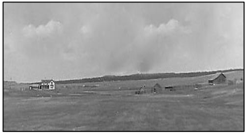
- 1865 to 1885 – Spring Valley post office. George Redman first postmaster, killed by Indians; replaced by Joseph Gile. Spring Valley most notably a stage stop from Frankstown to Colorado City (Frankstown and Gile Station Wagon and Barnum & Company stage). Had a school, an active grange hall, and livery/blacksmith.
- 1865 to 1870 – Indian unrest following Treaty of Fort Wise relegating Cheyenne and Arapaho to a reservation between the Arkansas River and Sand Creek. Some estimate over 200 settlers killed in Colorado during this period, including along the Divide.
- 1869 – First settlers in Gwillimville (Gwillim Rees Gwillim, Richard Gwillim in 1871). Community located in the meadow of the West Cherry Creek near present-day Walker Road and Highway 83 and included a creamery, cheese factory, school, church, post office, (1878-1890), a blacksmith and saloon.
– Ornate Victorian house of Gwillim Rees Gwillim finished in Gwillimville. People came from miles around to admire.
– Much of the land on the Divide is acquired by William Jackson Palmer as the Colorado Pinery Trust to supply materials for his Denver & Rio Grande Railroad and adjoining cities.
– Husted is established as a rail station named after Calvin Husted, a successful lumber man of the area. Located about six miles south of Monument near what is now the north entrance to the Air Force Academy. Survived until 1958 when it was displaced by the Air Force Academy. - 1870 to 1880’s – Timber industry growing to supply materials for railroads, cities and mines. Over time, more than 40 sawmills operated in Black Forest with lumberjacks (called hacks) often living in dugouts throughout the forest. Ranches develop such as the Grandview, the KKK (Tannebaum, Pine Cone), Bar X, Evergreen (Allen, Shamrock), and Stout.
- 1870 – General Palmer hired Samuel Stout to manage the Colorado Pinery Trust. The Stout Ranch was located on the current Flying Horse Ranch subdivision.
– Jotham Lincoln was attacked and killed by Indians on his ranch in Spring Valley. Lincoln Mesa was named for him. - 1870 to 1946 – Spring Valley School District #3. Located at Spring Valley Road and Lorraine Road.
- 1871 – Pat Murphy walked overnight to Denver to secure his claim to home-stead land near Gwillimville. He was a beloved bachelor on the Divide who is well known for walking everywhere, stating that he was in a hurry. Each year he hiked Pikes Peak and lived to be 105 years old.
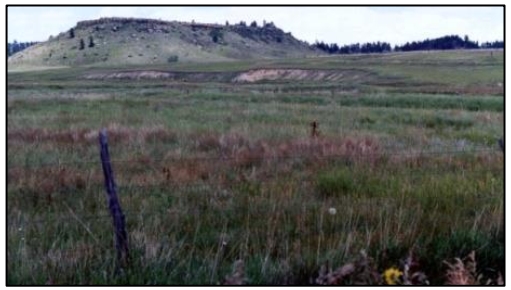
- 1872 – Table Rock community established and included a post office (1873-1893), tore, creamery, church and school. Located near Table Rock Mesa on the East Cherry Creek; later moved a few miles south along present-day Walker Road between Bar X Road and N. Black Forest Road.
– Table Rock Cemetery established on part of the Russell homestead. The earliest grave dated 1872 for Samuel S. Meek.
– Eastonville est. first as McConnellsville, then Eastin, then Easton, and finally Eastonville in 1883. Nine passenger trains and numerous freights passed through daily from Pueblo to Elbert, Elizabeth and Parker. Eastonville was a bustling town with two stores, telephone office, drug store, post office, blacksmith, barber, creamery, butcher, three lodges, a school, three churches, racetrack, paper.
- 1874 to 1877 – Grasshopper infestation destroyed many crops and implements.
- 1874 to 1951 – Columbine School District #26 (consolidated in 1951 with Lewis-Palmer #38). Located near Furrow Road on County Line.
- 1874 to 1951 – Table Rock School District #18 (closed 1951 and students sent to Lewis Palmer #38)
- 1876 – Colorado becomes a state.
– A railroad flag stop is established at Pring, three miles south of Monument (on the west side of I-25 on Baptist Road). - 1877 – Scarlet fever epidemic
– Spring Valley Cemetery officially created (earliest graves 1870). - 1877 to 1935 – The Divide was famous for its blue-ribbon champion dryland potatoes.
- 1878 to 1880’s – Prize winning cheeses: Black Canyon from Spring Valley; Black Diamond from Gwillimville; Blue Hill from Eastonville.
- 1880 – Diphtheria epidemic
- 1880 to 1938 – Elton School (District #27) located on Steppler Road. The building was moved to a local farm and used as a shed.
- 1881 – Calvin Husted continues to acquire land on the Divide including his ranch on the southwest end of Black Forest which he called Evergreen Ranch (later known as the Allen Ranch and today the Shamrock Ranch).
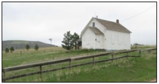
- 1881 to 1920 – Gwillimville School District #11. Building moved to the Monument Presbyterian Church. Later it was moved near the Village Inn in Monument where it served as the Chamber of Commerce for several years. The building is still there.
- 1885 – Small pox epidemic
- 1887 – The Divide Board of Trade – comprised of W. E. Meek, M. F. Olds, G. R. Gwillim, A. B. McConnell, R. J, Gwillim was formed to promote the Divide to the rest of the nation publishing “the Great Divide Natural Farming Land of Colorado” in 1889.
- 1887 to 1896 – The Divide Board of Trade partnered with Colorado State University to create The Divide Experiment Station on a forty acre parcel of land about a mile west of Table Rock Mesa with the purpose of collecting weather data and to improve methods of farming in the region.
- 1894 – Williams Cheese Factory, located at Cherry.
– Spring Valley Cheese Company (later known as Tipperary where community dances and parties were held). - 1909 – Two passenger trains collide near Husted killing eleven, injuring sixty-two.
- 1910 – Gutshall/Sanders home near northern Black Forest Road and Walker Road was renovated to become a 13-room inn in anticipation of a rumored railroad coming through. That never happened and it remains a private residence.
- 1912 to 1938 – Pine Grove School District #27, located on east County Line. Building moved in 1998 to the grounds of Kilmer Elementary School on Walker Road to serve as a living history, one-room school.
- 1914 – Train wreck near Husted when southbound struck a northbound train.
- 1917 – WW I entered by the U. S. April 6
- 1918 – Influenza epidemic (Spanish Flu)
- 1925 – Cherry Homemakers established as part of the Colorado State University Extension program.
- 1920’s to 1933 – Stills spotted the area along West Cherry Creek during Prohibition.
- 1920’s to 1935 – Potato blight strikes the eastern Divide crippling the potato crop.
- 1925 – Brentwood Country Club formed at the northern edge of Black Forest to be a state-of-the-art club with golf, croquet, cards, a pool, library, clubhouse, and ballroom. Failed to materialize due to Cont. stock market crash of 1929 but foundations and arch remain.
- Late 1930’s – Phone service comes to the Divide (east of Monument). Party lines remained until the 1970’s.
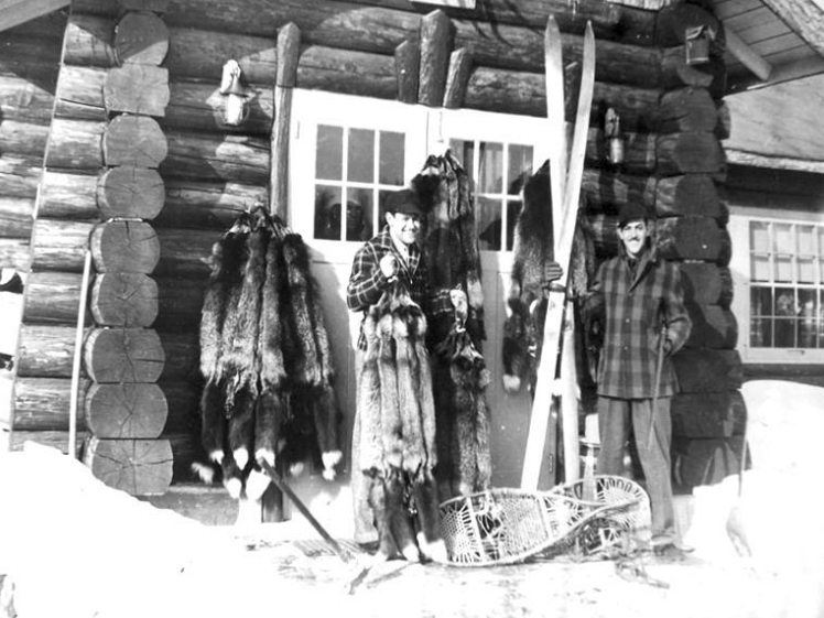
- 1930’s to 1947 – Fox farms became numerous throughout the Divide specializing in exotic black, silver, and platinum furs desired by the most fashionable. Trade with Russia in 1947 abruptly ended the fur businesses and the foxes were released into the wild. Descendants still roam the Divide area.
- 1940 to 1945 – Electricity comes to the Divide (east of Monument).
- 1941 – WW II entered on Dec. 7th
- 1942 – Ned McLean Jr. builds Spanish-style stucco ranch house just southeast of current Old North Gate Road known as the Flying Horse. His mother owned the Hope Diamond. The actor Jimmy Stewart often frequented the ranch. Later owned by Ben Snow, owner of the Western Horseman magazine.
- 1950 – Fire on the northwest end of Black Forest contained to a few hundred acres by locals with their own farm equipment.
- 1955 – U.S.A.F. Academy begins construction bringing growth to the area.
- 1959 – 1st class of cadets graduates at AFA
- 1970 to 1972 – The Museum of the West was founded in 1970; name changed to The Western Museum of Mining and Industry in 1972. Located at the I-25 and North Gate Road interchange; dedicated to preserving and protecting mining history. The Queen Anne style ranch house which belonged to the Reynolds family of the Husted community is on the museum grounds.
- 2013 – Black Forest fire burned 14,280 acres, destroyed 489 homes, and two people were killed.
Compiled by: Susan Koch & The Lucretia Vaile Museum